
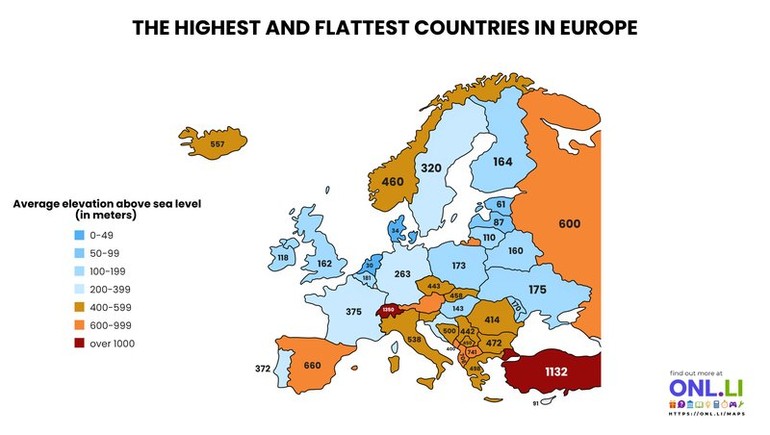
Europe is often associated with the Alps, Pyrenees, and Carpathians, but its overall landscape is far more varied than many people realize. This map compares the average elevation of European countries, revealing a striking contrast between mountainous nations in the south and flatter countries across the northern plains. Rather than focusing on the highest peaks, it highlights the average height of each country's terrain above sea level.
Switzerland stands out with an average elevation of around 1,350 meters (4,429 feet), making it Europe's highest country on average thanks to the Alps covering much of its territory. Turkey (partly in Europe) and Spain also rank among the continent's highest due to their extensive plateaus and mountain systems. At the opposite end of the scale, Denmark averages just 34 meters (112 feet) above sea level, making it Europe's flattest country, while the Netherlands, Belgium, and the Baltic states also have relatively low average elevations.
One surprising pattern is that some countries famous for mountains are not necessarily the highest on average. Norway, for example, has dramatic fjords and towering peaks but also extensive lower coastal areas that reduce its overall average elevation. Meanwhile, countries such as Serbia, North Macedonia, and Montenegro rank much higher than many people expect because much of their territory consists of uplands and rugged mountain ranges.
Average elevation influences far more than scenery. It affects climate, agriculture, transportation, settlement patterns, and even biodiversity. Flatter countries generally have more land suitable for farming and urban development, while higher countries often experience cooler temperatures, steeper terrain, and greater reliance on mountain infrastructure.