
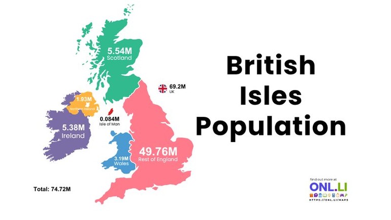
The British Isles are home to nearly 75 million people, but the population is not evenly distributed. The figures shown in the map reveal a strong concentration in England, while Scotland, Wales, Ireland, Northern Ireland, and the Isle of Man account for much smaller shares.
England Has the Largest Population
The rest of England has an estimated population of 49.76 million, making it the most heavily populated area shown on the map.
This figure does not include Wales, Scotland, or Northern Ireland, which are separate constituent countries of the United Kingdom. England’s large population reflects the presence of major urban areas such as London, Birmingham, Manchester, Liverpool, Leeds, and Bristol.
England also has a higher population density than most other parts of the British Isles, especially in London, southeastern England, and the Midlands.
Scotland Covers More Land Than Its Population Suggests
Scotland has a population of approximately 5.54 million. Although it occupies a large portion of Great Britain, it has far fewer residents than England.
Much of Scotland’s population is concentrated in the Central Belt, particularly around Glasgow and Edinburgh. The Highlands, islands, and northern regions are much more sparsely populated because of their mountainous landscapes, remote communities, and limited urban development.
Wales Has Just Over Three Million Residents
Wales has an estimated population of 3.19 million. Most residents live in southern Wales, where cities such as Cardiff, Swansea, and Newport are located.
The northern and central parts of Wales contain large rural and mountainous areas. This helps explain why the population is concentrated in a relatively small number of urban and coastal communities.
Ireland’s Population Is Divided Between Two Jurisdictions
The island of Ireland has a combined population of about 7.31 million based on the figures shown.
The Republic of Ireland accounts for approximately 5.38 million people, while Northern Ireland has around 1.93 million residents.
The Republic of Ireland is an independent country, while Northern Ireland is part of the United Kingdom. Dublin is the largest population center in the Republic, while Belfast is the largest city in Northern Ireland.
The Isle of Man Has a Small Population
Located in the Irish Sea between Great Britain and Ireland, the Isle of Man has an estimated population of about 84,000.
It is not part of the United Kingdom. Instead, it is a self-governing Crown Dependency with its own parliament, laws, and administrative system. Its population is concentrated around Douglas, the island’s capital and largest town.
The United Kingdom Accounts for Most Residents
The map gives the United Kingdom a population of approximately 69.2 million. This includes England, Scotland, Wales, and Northern Ireland.
England accounts for the overwhelming majority of the UK population. Scotland, Wales, and Northern Ireland together represent a much smaller portion, despite covering a substantial amount of territory.
A Total Population of Nearly 75 Million
The combined population displayed on the map is 74.72 million. This total includes:
- England
- Scotland
- Wales
- Northern Ireland
- The Republic of Ireland
- The Isle of Man
The figures show how strongly the region’s population is concentrated in England and around major cities. Large rural areas in Scotland, Wales, and Ireland remain comparatively lightly populated.
Understanding the Term “British Isles”
The term “British Isles” is commonly used as a geographic description for Great Britain, Ireland, and nearby islands. However, it can be politically sensitive, particularly in Ireland.
It is also important not to confuse the British Isles with the United Kingdom. The United Kingdom includes England, Scotland, Wales, and Northern Ireland, while the Republic of Ireland is a separate country. The Isle of Man is also politically separate as a Crown Dependency.
A Region of Major Population Contrasts
The map highlights a clear contrast between densely populated urban regions and large areas with relatively few residents. England dominates the population totals, while Scotland, Wales, Ireland, and the smaller islands contribute far lower numbers.
These differences have shaped transportation, housing, economic development, political representation, and public services throughout the region.