
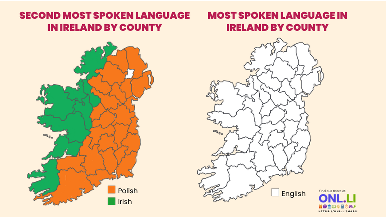
A county-by-county language map of Ireland makes one thing clear right away: English is the most spoken language in every county shown.
That part is not surprising. English is the main language of daily life in Ireland. It is used in schools, workplaces, media, government, and everyday conversation. Even though Irish has official status and deep cultural importance, English remains the language most people use most often.
The more interesting part of the graphic is the second map. It shows the second most spoken language by county, and that map is split between two languages: Irish and Polish.
Irish appears across much of the west and northwest. Polish appears across many counties in the east, midlands, south, and northeast. That contrast tells a bigger story about Ireland’s history, culture, migration, and modern identity.
English Leads Across Ireland
The right side of the graphic is simple. Every county is shaded white, with English listed as the most spoken language.
This reflects modern Ireland’s language reality. English became dominant over centuries and is now the main language for most people in the country. It is the language most commonly heard in homes, shops, offices, classrooms, and public life.
Irish still holds a special place. It is taught in schools, used in public signs, heard in parts of the country, and strongly connected to national identity. Still, the graphic shows that Irish does not overtake English in any county.
English remains the common language across the island.
The Second-Language Map Tells a More Detailed Story
The left side of the graphic is where the map becomes more revealing.
It shows two colors. Orange represents Polish. Green represents Irish.
The green areas are mostly found in the west and northwest of Ireland. The orange areas cover much of the east, central region, northeast, and south.
This split is meaningful because the two languages represent very different parts of Ireland’s story.
Irish is the country’s native language. It connects to older traditions, place names, folklore, literature, music, and national identity.
Polish reflects modern immigration. It became especially visible in Ireland after Poland joined the European Union in 2004. Many Polish people moved to Ireland for work, study, and family opportunities, and Polish became one of the most widely spoken non-English languages in the country.
Why Irish Shows Strongly in the West
Irish appears as the second most spoken language in many western counties. That pattern makes sense because the west of Ireland includes several areas where Irish has remained culturally strong.
These areas are often associated with the Gaeltacht, where Irish has a stronger presence in community life. Counties such as Galway, Mayo, Donegal, Kerry, Cork, and Waterford include regions where Irish has long had cultural and linguistic importance.
In these places, Irish may be heard more often in schools, local events, radio, music, and community settings. It also appears in signs, place names, and cultural programs.
Even when most residents speak English in daily life, Irish can still rank highly because many people learn it, use it, or identify with it as part of local heritage.
That helps explain the green cluster across the west and northwest.
Why Polish Covers So Much of the Map
Polish appears as the second most spoken language in many counties across Ireland. This reflects a major change in Ireland’s population during the 2000s and after.
When Poland joined the European Union, Ireland became a popular destination for Polish workers and families. The Irish economy offered jobs in construction, services, manufacturing, food production, agriculture, hospitality, and other fields.
Over time, Polish communities became part of daily life in towns and cities across the country. Polish shops, churches, schools, community groups, and cultural events helped the language remain visible.
That is why Polish appears across so many counties in the graphic. It is not limited to Dublin or one major city. It shows up across large parts of the country, which points to how widely Polish-speaking communities settled in Ireland.
A Map of Heritage and Modern Change
The graphic works because it shows two versions of Ireland at the same time.
Irish represents the older language story. It reaches back into Ireland’s earliest cultural identity and remains deeply connected to how the country understands itself.
Polish represents a newer part of the national story. It reflects Ireland’s modern connection to Europe and the impact of immigration on local communities.
The map does not suggest that one story replaces the other. Instead, it shows how both can exist together. Ireland has an old linguistic heritage, and it also has newer language communities that have helped shape modern life.
The West-East Pattern
The map also shows a loose west-east divide.
The west and northwest lean more toward Irish as the second most spoken language. The east, midlands, and much of the south lean more toward Polish.
This pattern lines up with broader historical and population trends. Western counties include many places where Irish has remained culturally important. Eastern and central counties include major employment areas, commuter towns, and growing communities that attracted migrants from Poland and elsewhere.
Of course, a county map simplifies reality. Each county includes towns, villages, cities, schools, workplaces, and families with different language backgrounds. A single color cannot show every language spoken there.
Still, the overall pattern gives a useful snapshot.
What the Graphic Does Not Show
The graphic focuses only on the most spoken language and the second most spoken language in each county. That means it leaves out many other languages spoken across Ireland.
Languages such as Lithuanian, Romanian, French, Spanish, Arabic, Chinese, Portuguese, Ukrainian, and others may have strong communities in certain places. They simply do not appear if they are not ranked first or second in a county.
That is important to remember. Modern Ireland is much more linguistically diverse than the map can fully show.
Many homes use languages other than English or Irish. Many schools have students who speak several languages. Many towns have communities with roots across Europe, Africa, Asia, and the Americas.
So while the graphic highlights English, Irish, and Polish, it only shows part of the wider language picture.
Why This Map Is Interesting
This graphic stands out because it makes a complex subject easy to understand.
The right map shows the dominance of English. The left map shows a much more layered picture, with Irish and Polish competing for second place depending on the county.
That contrast says a lot.
Irish carries historic and cultural meaning. Polish reflects demographic change and modern migration. English remains the main shared language across the country.
Together, these maps show Ireland as a place shaped by older traditions and newer communities. Language is one of the clearest ways to see that change.
Final Thoughts
The county language map tells a simple but meaningful story.
English is the most spoken language in every county shown. Irish remains especially strong as a second language in much of the west and northwest. Polish appears as the second most spoken language across many other counties, showing the lasting influence of Polish immigration in modern Ireland.
In one graphic, we can see Ireland’s past and present side by side. The green areas point to native language heritage. The orange areas point to newer communities that have become part of Irish life. The white map reminds us that English remains the country’s main everyday language.
That combination makes the language map more than a set of colors. It is a snapshot of how Ireland speaks today.