
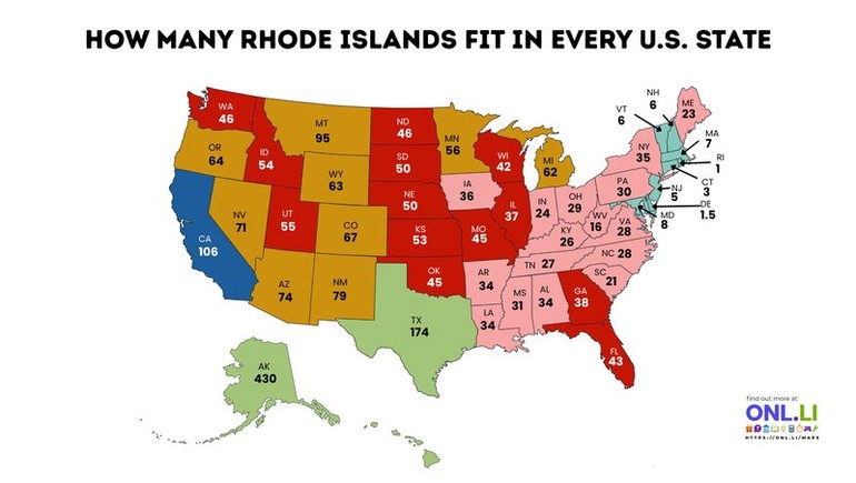
Rhode Island may be America's smallest state by land area, but it has become one of the country's favorite measuring sticks for comparing size. This map shows how many Rhode Islands could fit inside every U.S. state, offering an easy way to visualize the enormous differences in area across the nation.
The numbers are based on land area comparisons rather than population or total area that includes water. Unsurprisingly, Alaska dominates the list, while the smallest states in the Northeast are only a few Rhode Islands in size. It's a fun reminder that the United States contains an incredible range of landscapes and scales.
Rhode Island: Small in Size, Big in History
Covering approximately 1,214 square miles (3,144 square kilometers), Rhode Island is the smallest state in the United States. Despite its size, it played a major role in American history as one of the original Thirteen Colonies and was the last colony to ratify the U.S. Constitution in 1790.
Its compact geography has made Rhode Island a popular benchmark whenever people want to compare the size of states, national parks, countries, or even large cities.
Alaska Is Larger Than Most People Realize
At the top of the map sits Alaska, where roughly 430 Rhode Islands could fit within its borders. Stretching from the temperate rainforests of the southeast to the Arctic Ocean, Alaska is by far the largest U.S. state, covering more than 663,000 square miles (1.7 million square kilometers).
Its sheer scale is often underestimated because many maps distort land sizes at high latitudes. In reality, Alaska is larger than Texas, California, and Montana combined.
The Lower 48 Show Huge Differences
Texas ranks second on the map, fitting approximately 174 Rhode Islands, while California can hold about 106. Many western states such as Montana, Arizona, Colorado, and Nevada also dwarf most of the eastern United States because of their vast land areas.
In contrast, densely populated northeastern states occupy much smaller footprints. Delaware fits only about 1.5 Rhode Islands, while Connecticut, New Jersey, Massachusetts, and Vermont are only a few times larger than America's smallest state.
Land Area Doesn't Equal Population
One interesting takeaway is that size and population are often unrelated. California is both one of the largest and most populous states, but Alaska, Montana, and Wyoming have enormous land areas despite relatively small populations.
Meanwhile, states such as New Jersey and Massachusetts rank among the nation's most densely populated despite covering comparatively little land.
A Simple Way to Visualize America's Scale
Using Rhode Island as a reference makes the vast differences between U.S. states much easier to understand than simply listing square miles. The comparison provides a relatable perspective on just how diverse the geography of the United States really is.
Maps like this show that America's states vary enormously in size. From tiny Rhode Island to massive Alaska, each state occupies a unique place on the country's geographic landscape.